
Case of the Disappeared
The Tauxenent or Dogue and Pamunkey of the Metropolitan Area (or DMV)
Today, Washington, DC still shares in a national issue of Crimes Against Humanity, the disappeared Indigenous population. America’s history against its indigenous people has continued since the arrival of their English predecessors in 1607. The newly formed Revolutionary Government continued its atrocities against millions of Native Americans. Today, the crimes continue with Disappeared and Murdered Native Women, to its murderous infection of imported pathogens (rats, diseased people and blankets), wars against humans they deemed “savages”, the 1924 Racial Integrity Act of Virginia which was exported to Washington, DC. This last act has contributed to the official disappearances of the city’s Tauxenent off to Dogue, and the Pamunkey descendants.
THE SURVIVORS
Today, hundreds of descendsnts of Native Americans who have been Indigenous to the DMV for thousands of years have disappeared from the records. Yet newcommers to our city had deemed them disappeared. The main reasons? There is no establishedDistrict of Columbia tribal government. Yet, their descendants are everywhere... just victims of Virginia's importes 1923 Racial Integrity Law (click to read a blog on "Surviving Document Genocide" by Rose Powhatan).
Moving in and out of the city proper for to live, work, or for schooling on all levels, was the norm. Ancestors also worked in local DC stone quarried (one in the National Zoo off Quarry Road, NW) whose stones were used in building DC structures like the interior of the Washington Monument, a Smithsonian building, the eves of the Capitol Rotunda, canals, and even Georgetown's "Exorcist steps".
 |
Pamunkeys in DC: (L-R) late Pamunkey Chief Willian (Bill) "Swift Eagle" Miles (stooping). Back row: Bill's late wife, Ann Miles; Bill's cousin, DC-born Georgia Mills Boston Jessup (Pamunkey) artist, DCPS School Administrator: Georgia's daughter, DC-born, resident Rose Powhatan (Tauxenebt/Pamunkey); woman representayive of the Islamic Center of Washington, DC. Bill and Ann visiting from the Pamunkey Reservation, stayed with Georgia in her Maryland home while on an official 1980s tribal business with the Islamic Center who had offered medical care for the reservation. |
 |
Photos: (Top) Georgia Mills Boston Jessup (Pamunkey) with her painting, "Rainy Night Downtown", Permanent Collection of National Women in the Arts, Washington, DC. (Middle) Bernie Boston (Tauxenent Councilman), White House photographer for the LA Times, with his Pulitzer nominated Vietnam Era bhoto "Flower Power". (Bottom) Back & front cook cover of a novel by Rose Powhatan's son, a Lawyer for the Arts, podcaster & author, Alexei Auld (Pamumkey/Tauxenent), born and educated in Washington, DC, an Columbia School of Law. |
All were proudly aware of their descent from the Dogue/Tauxenent, Wampanoag, and Pamunkey, the leading nation in the Powhatan Paramouncy with America's oldest reservation in King William County, Virginia, three counties in Southern Maryland (the current township of Pomonkey, MD). The Pamunkey counted Wahunsennachaw, his brother, Opichancanoegh, the War Chief, his niece Cockacoesque (the Queen of Pamunkey & DC), and Pocahontas as tribal members. Their Paramountcy foght thee Anglo-Powhatan Wars of Homeland Security, signing pivotal treaties with the spreading British Empire.
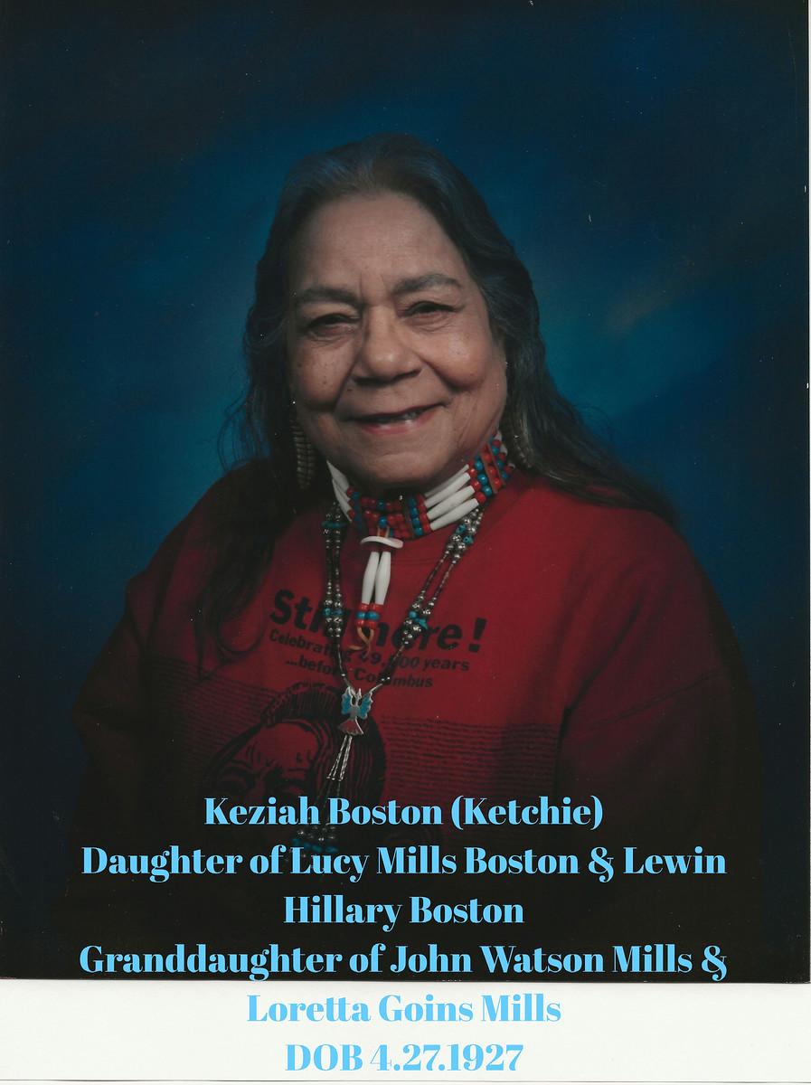 Above: A photo of the late Tauxenent’s Chief Keziah Boston who was elected to that position along with two Assistants to the Chief, Billy Payne and Rose Powhatan. She, her assistants, and the tribe's council were the first installed since the recorded weroansquaw, Keziah Powhatan and her Fairfax County warriors burned down the county’s courthouse around 1744. Chief Keziah Boston was of Dogue, Pamunkey, and Wampanoag descent, marking the revival of Northern Virginia’s tribal nation, the northernmost national member of the historic 32-34 members of the Powhatan Paramountcy. These nations continued to intermarry over the centuries, creating multiple kinships.
 |
| Assistant to the Chief, Rose Powhatan |
 |
| The Tauxenent/Dogue Weroansquaw, Keziah Powhatan was memorialized by her descendant, Rose Powhatan in a 2023-2024 Native American art exhibition at the National Gallery of Art, Washington, DC, her hometown and ancestral territory, the northernmost segment of the historic Powhatan Paramountcy. |
 |
| D.A.R. Plaque, Tyson's Corner, Vienna, Virginia commemorating the act of Werowansquaw Keziah Powhatan and her warriors as "Indian hostilities". |
 |
| A proposed Washington, DC Tauxenent/Pamunkey Land Acknowledgement plaque. |
 |
| A concept for a monument to Wahunsenachaw or the second Powhatan, who had inhereted a group of eight Algonquian nations from his father, the First Powhatan in the Tidewater area of Virginia. By his 60s, Wahunsenachaw had created a confederation of over 32 nations to creat a Paramouncy that the arriving English considered to be a kingdom with princes and princesses. The Tiber Creek in the Dogue territory on a hill, which becamre Capitol Hill in Washington, DC was his favotite place to caucus with surrounding nations. (See Washington Post map below). |
The sad fact is that the American words, "Dogue" and "Tauxenent" are not familiar names to most Washingtonians...
Or even in the Metropolitan DC Area.- Not to the general public.
- Not to the Media.
- Not to the DC Government.
- Not to the Federal Government and its workers.
- Not even to the private and Public Schools, or the many universities and other institutions of higher learning.
 |
| John Smith's Map of the Virginia Territory that includes Powhatan's domain of 32-34 nations known historically as a Kingdom, Confederacy, or "Chiefdom", along with the "tribes" of the area. |
Enlargement of the Washington Post's 2007 map of the Powhatan Confederacy's Dogue or Tauxenent Territory that included parts of today's Northern Virginia and Washington, DC.

 |
1607: Powhatan Land and Water Areas = Approximately 16,000 square miles [Note: A Washington Post map by Gene Thorpe dated December 13, 2006, showed that the above land and water areas were between 18,700 to 19,250 square miles.] |
The Racial Integrity Law has contributed to the confusion of the racial identities of many individuals in the DC Metropolitan Area's population. With the influx of newly arriving populations, the issue of Indigenous survival is not generally known. Extinction of the indigenous people is more commonly believed by "newcomers", but is not limited to them.
The historical evidence shows that the two major Amerindian Algonquian nations were within today's finalized boundaries of Washington, DC. They are Tauxenent on both banks of the Potomac River and were the Nacotchtanks (Anacostins) on the Anacostia River. Only the descendants of the Tauxenents can be found in both DC proper and across the river in Fairfax and other counties of Northern Virginia. The historic Nacotchtanks were seen as leaders in the beaver fur trade, a commodity coveted by northern rival Native nations and the newly arrived English. The Nacotchtanks' main town was bombarded and destroyed by the English and their Potowomek allies (a Stafford County [Powhatan] nation for whom the River of the Cohonks was renamed, "Potomac", and the co-kidnappers of Pocahontas). The remnant Nacotchtanks survivors left the area to seek refuge and seemingly assimilated within other tribes, probably to the north and west.
For those still here, one just has to know the family names of the surviving Tauxenents of the Tri-state area. Unfortunately, currently, there is widespread confusion by some, especially a few writers and some groups who have belatedly laid claim on DC's Indigenous identity.
==============================================
NOTES:
 |
* Land |
